|
WATER
RIGHTS - Clarion Housing Group and Thakeham
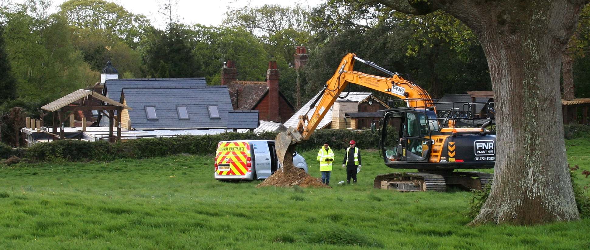
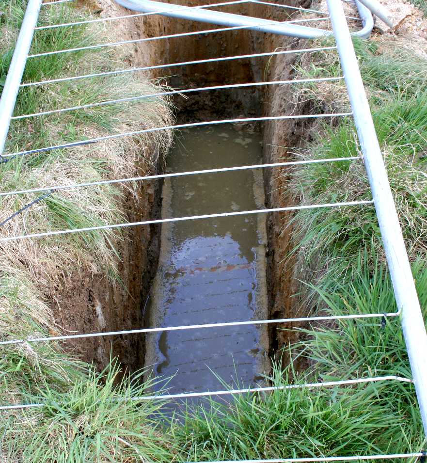
Homes are in danger of spoiling an ancient well that supplies water
to many concerns in this vicinity. In the picture you can see a hired
digger scooping out trenches to test drainage by pouring in water and
measuring the rate of absorption by the soil. It seems to us that if you
build houses on the ground that feeds the ancient well, that
contamination from garden treatments such as Roundup and engine oils,
etc., will find its way into this well leading to claims against the
owners of the houses who would have been sold a pup, and/or against the
Council for approving the proposal, by way of a negligence claim, and/or
against the vendors or developers. Any way you look at it the developers
and Council concerned should take steps to ensure that no development
takes place until the proper tests and evaluations have been completed,
and after that stage, to ensure that any houses built in this location
will not be on a path that includes the water
table that feeds the ancient well.
Any
failure to conduct the proper tests and house situation, along with safe
sewage disposal, may tempt the Secretary
of State to call in the application. We imagine that all of those
with a financial interest in this piece of greenbelt will want to
resolve issues before it starts to get complicated.
ANNEX
2 GLOSSARY A - Z INDEX
Affordable housing: Social rented, affordable rented and intermediate housing,
provided to eligible households whose needs are not met by the market. Eligibility
is determined with regard to local incomes and local house prices. Affordable
housing should include provisions to remain at an affordable price for future
eligible households or for the subsidy to be recycled for alternative affordable
housing provision.
Social rented housing: is owned by local authorities and private registered providers
(as defined in section 80 of the Housing and Regeneration Act 2008), for which
guideline target rents are determined through the national rent regime. It may also
be owned by other persons and provided under equivalent rental arrangements to
the above, as agreed with the local authority or with the Homes and Communities
Agency.
Affordable rented housing: is let by local authorities or private registered providers
of social housing to households who are eligible for social rented housing.
Affordable Rent is subject to rent controls that require a rent of no more than 80%
of the local market rent (including service charges, where applicable).
Intermediate housing: is homes for sale and rent provided at a cost above social
rent, but below market levels subject to the criteria in the Affordable Housing
definition above. These can include shared equity (shared ownership and equity
loans), other low cost homes for sale and intermediate rent, but not affordable
rented housing.
Homes that do not meet the above definition of affordable housing, such as “low
cost market” housing, may not be considered as affordable housing for planning
purposes.
Aged or veteran tree: A tree which, because of its great age, size or condition is
of exceptional value for wildlife, in the landscape, or culturally.
Air Quality Management Areas: Areas designated by local authorities because
they are not likely to achieve national air quality objectives by the relevant deadlines.
Ancient woodland: An area that has been wooded continuously since at least
1600 AD.
Archaeological interest: There will be archaeological interest in a heritage asset if
it holds, or potentially may hold, evidence of past human activity worthy of expert
investigation at some point. Heritage assets with archaeological interest are the
primary source of evidence about the substance and evolution of places, and of
the people and cultures that made them.
Article 4 direction: A direction which withdraws automatic planning permission
granted by the General Permitted Development Order.
Best and most versatile agricultural land: Land in grades 1, 2 and 3a of the
Agricultural Land Classification.
Birds and Habitats Directives: European Directives to conserve natural habitats
and wild fauna and flora.
Climate change adaptation: Adjustments to natural or human systems in
response to actual or expected climatic factors or their effects, including from
changes in rainfall and rising temperatures, which moderate harm or exploit
beneficial opportunities.
Climate change mitigation: Action to reduce the impact of
human activity on the climate system, primarily through reducing greenhouse gas
emissions.
Coastal Change Management Area: An area identified in Local Plans as likely to
be affected by coastal change (physical change to the shoreline through erosion,
coastal landslip, permanent inundation or coastal accretion).
Conservation (for heritage policy): The process of maintaining and managing
change to a heritage asset in a way that sustains and, where appropriate,
enhances its significance.
Community Forest: An area identified through the England Community Forest
Programme to revitalise countryside and green space in and around major conurbations.
Community Infrastructure Levy: A levy allowing local authorities to raise funds
from owners or developers of land undertaking new building projects in their area.
Community Right to Build Order: An Order made by the local planning
authority (under the Town and Country Planning Act 1990) that grants planning
permission for a site-specific development proposal or classes of development.
Competent person (to prepare site investigation information): A person with
a recognised relevant qualification, sufficient experience in dealing with the type(s) of pollution or land instability, and
membership of a relevant professional organisation.
Decentralised energy: Local renewable energy and local low-carbon energy
usually but not always on a relatively small scale encompassing a diverse range of
technologies.
Designated heritage asset: A World Heritage Site, Scheduled Monument, Listed
Building, Protected Wreck Site, Registered Park and Garden, Registered Battlefield
or Conservation Area designated under the relevant legislation.
Development plan: This includes adopted Local Plans, neighbourhood plans and
the London Plan, and is defined in section 38 of the Planning and Compulsory
Purchase Act 2004. (Regional strategies remain part of the development plan until
they are abolished by Order using powers taken in the Localism Act. It is the
government’s clear policy intention to revoke the regional strategies outside of
London, subject to the outcome of the environmental assessments that are
currently being undertaken.)
Economic development: Development, including those within the B Use Classes,
public and community uses and main town centre uses (but excluding housing
development).
Ecological networks: These link sites of biodiversity importance.
Ecosystem services: The benefits people obtain from ecosystems such as, food,
water, flood and disease control and recreation.
Edge of centre: For retail purposes, a location that is well connected and up to
300 metres of the primary shopping area. For all other main town centre uses, a
location within 300 metres of a town centre boundary. For office development,
this includes locations outside the town centre but within 500 metres of a public
transport interchange. In determining whether a site falls within the definition of
edge of centre, account should be taken of local circumstances.
Environmental Impact Assessment: A procedure to be followed for certain
types of project to ensure that decisions are made in full knowledge of any likely
significant effects on the environment.
European site: This includes candidate Special Areas of Conservation, Sites of
Community Importance, Special Areas of Conservation and Special Protection
Areas, and is defined in regulation 8 of the Conservation of Habitats and Species
Regulations 2010.
Geodiversity: The range of rocks, minerals, fossils, soils and landforms.
Green infrastructure: A network of multi-functional green space, urban and
rural, which is capable of delivering a wide range of environmental and quality of
life benefits for local communities.
Heritage asset: A
building, monument, site, place, area or landscape identified as having a degree of significance meriting consideration in planning decisions,
because of its heritage interest. Heritage asset includes designated heritage assets
and assets identified by the local planning authority (including local listing).
Heritage Coast: Areas of undeveloped coastline which are managed to conserve
their natural beauty and, where appropriate, to improve accessibility for visitors.
Historic environment: All aspects of the environment resulting from the
interaction between people and places through time, including all surviving
physical remains of past human activity, whether visible, buried or
submerged, and landscaped and planted or managed flora.
Historic environment record: Information services that seek to provide access to
comprehensive and dynamic resources relating to the historic environment of a
defined geographic area for public benefit and use.
Inclusive design: Designing the built environment, including buildings and their
surrounding spaces, to ensure that they can be accessed and used by everyone.
Instrumentation operated in the national interest: Includes meteorological
and climate monitoring installations, satellite and radio communication, defence
and national security sites and magnetic calibration facilities operated by or on
behalf of the Government, delegated authorities or for defence purposes.
International, national and locally designated sites of importance for
biodiversity: All international sites (Special Areas of Conservation, Special
Protection Areas, and Ramsar sites), national sites (Sites of Special Scientific
Interest) and locally designated sites including Local Wildlife Sites.
Local Development Order: An Order made by a local planning authority (under
the Town and Country Planning Act 1990) that grants planning permission for a
specific development proposal or classes of development.
Local Enterprise Partnership: A body, designated by the Secretary of State for
Communities and Local Government, established for the purpose of creating or
improving the conditions for economic growth in an area.
Local Nature Partnership: A body, designated by the Secretary of State for
Environment, Food and Rural Affairs, established for the purpose of protecting and
improving the natural environment in an area and the benefits derived from it.
Local planning authority: The public authority whose duty it is to carry out
specific planning functions for a particular area. All references to local planning
authority apply to the district council, London borough council, county council,
Broads Authority, National Park Authority and the Greater London Authority, to the
extent appropriate to their responsibilities.
Local Plan: The plan for the future development of the local area, drawn up by
the local planning authority in consultation with the community. In law this is
described as the development plan documents adopted under the Planning and
Compulsory Purchase Act 2004. Current core strategies or other planning policies,
which under the regulations would be considered to be development plan
documents, form part of the Local Plan. The term includes old policies which have
been saved under the 2004 Act.
Main town centre uses: Retail development (including warehouse clubs and
factory outlet centres); leisure, entertainment facilities the more intensive sport and
recreation uses (including cinemas, restaurants, drive-through restaurants, bars and
pubs, night-clubs, casinos, health and fitness centres, indoor bowling centres, and
bingo halls); offices; and arts, culture and tourism development (including theatres,
museums, galleries and concert halls, hotels and conference facilities).
Major Hazards: Major hazard installations and pipelines, licensed explosive sites
and nuclear installations, around which Health and Safety Executive (and Office for
Nuclear Regulation) consultation distances to mitigate the consequences to public
safety of major accidents may apply.
Minerals of local and national importance: Minerals which are necessary to
meet society’s needs, including aggregates, brickclay (especially Etruria Marl and
fireclay), silica sand (including high grade silica sands), cement raw materials,
gypsum, salt, fluorspar, shallow and deep-mined coal, oil and gas (including
hydrocarbons), tungsten, kaolin, ball clay, potash and local minerals of importance
to heritage assets and local distinctiveness.
Mineral Safeguarding Area: An area designated by Minerals Planning
Authorities which covers known deposits of minerals which are desired to be kept
safeguarded from unnecessary sterilisation by non-mineral development.
National Trails: Long distance routes for walking, cycling and horse riding.
Nature Improvement Areas: Inter-connected networks of wildlife habitats intended to re-establish thriving wildlife populations and help species respond to
the challenges of climate change.
Neighbourhood Development Order: An Order made by a local planning
authority (under the Town and Country Planning Act 1990) through which Parish
Councils and neighbourhood forums can grant planning permission for a specific
development proposal or classes of development.
Neighbourhood plans: A plan prepared by a Parish Council or Neighbourhood
Forum for a particular neighbourhood area (made under the Planning and Compulsory Purchase Act 2004).
Older people: People over retirement age, including the active, newly-retired
through to the very frail elderly, whose housing needs can encompass accessible,
adaptable general needs housing for those looking to downsize from family
housing and the full range of retirement and specialised housing for those with
support or care needs.
Open space: All open space of public value, including not just land, but also areas
of water (such as rivers, canals, lakes and reservoirs) which offer important
opportunities for sport and recreation and can act as a visual amenity. Original building: A building as it existed on 1 July 1948 or, if constructed after
1 July 1948, as it was built originally.
Out of centre: A location which is not in or on the edge of a centre but not
necessarily outside the urban area.
Out of town: A location out of centre that is outside the existing urban area.
People with disabilities: People have a disability if they have a physical or mental
impairment, and that impairment has a substantial and long-term adverse effect
on their ability to carry out normal day-to-day activities. These persons include, but are not
limited to, people with ambulatory difficulties, blindness, learning difficulties, autism and mental health needs.
Planning condition: A condition imposed on a grant of planning permission (in
accordance with the Town and Country Planning Act 1990) or a condition included
in a Local Development Order or Neighbourhood Development Order.
Planning obligation: A legally enforceable obligation entered into under section
106 of the Town and Country Planning Act 1990 to mitigate the impacts of a
development proposal.
Playing field: The whole of a site which encompasses at least one playing pitch as
defined in the Town and Country Planning (Development Management Procedure)
(England) Order 2010.
Pollution: Anything that affects the quality of land, air, water or soils, which might lead to an
adverse impact on human health, the natural environment or general amenity. Pollution can arise from a range of emissions, including smoke, fumes,
gases, dust, steam, odour, noise and light.
Previously developed land: Land which is or was occupied by a permanent
structure, including the curtilage of the developed land (although it should not be
assumed that the whole of the curtilage should be developed) and any associated
fixed surface infrastructure. This excludes: land that is or has been occupied by
agricultural or forestry buildings; land that has been developed for minerals
extraction or waste disposal by landfill purposes where provision for restoration
has been made through development control procedures; land in built-up areas
such as private residential gardens, parks, recreation grounds and allotments; and
land that was previously-developed but where the remains of the permanent
structure or fixed surface structure have blended into the landscape in the process
of time.
Primary shopping area: Defined area where retail development is concentrated
(generally comprising the primary and those secondary frontages which are
adjoining and closely related to the primary shopping frontage).
Primary and secondary frontages: Primary frontages are likely to include a high
proportion of retail uses which may include food, drinks, clothing and household
goods. Secondary frontages provide greater opportunities for a diversity of uses
such as restaurants, cinemas and businesses.
Priority habitats and species: Species and Habitats of Principle Importance
included in the England Biodiversity List published by the Secretary of State under
section 41 of the Natural Environment and Rural Communities Act 2006. Ramsar sites:
Wetlands of international importance, designated under the 1971
Ramsar Convention.
Renewable and low carbon energy: Includes energy for heating and cooling as
well as generating
electricity. Renewable energy covers those energy flows that occur naturally and repeatedly in the environment – from the wind, the fall of
water, the movement of the oceans, from the sun and also from biomass and deep
geothermal heat. Low carbon technologies are those that can help reduce
emissions (compared to conventional use of fossil fuels).
Rural exception sites: Small sites used for affordable housing in perpetuity where
sites would not normally be used for housing. Rural exception sites seek to address
the needs of the local community by accommodating households who are either
current residents or have an existing family or employment connection. Small
numbers of market homes may be allowed at the local authority’s discretion, for
example where essential to enable the delivery of affordable units without grant
funding.
Safeguarding zone: An area defined in Circular 01/03: Safeguarding aerodromes,
technical sites and military explosives storage areas, to safeguard such sites.
Setting of a heritage asset: The surroundings in which a heritage asset is
experienced. Its extent is not fixed and may change as the asset and its
surroundings evolve. Elements of a setting may make a positive or negative
contribution to the significance of an asset, may affect the ability to appreciate
that significance or may be neutral.
Shoreline Management Plans: A plan providing a large-scale assessment of the
risk to people and to the developed, historic and natural environment associated
with coastal processes.
Significance (for heritage policy): The value of a heritage asset to this and
future generations because of its heritage interest. That interest may be
archaeological, architectural, artistic or historic. Significance derives not only from a heritage asset’s physical presence,
but also from its setting.
Special Areas of Conservation: Areas given special protection under the
European Union’s Habitats Directive, which is transposed into UK law by the
Habitats and Conservation of Species Regulations 2010.
Special Protection Areas: Areas which have been identified as being of
international importance for the breeding, feeding, wintering or the migration of
rare and vulnerable species of birds found within European Union countries. They
are European designated sites, classified under the Birds Directive.
Site investigation information: Includes a risk assessment of land potentially
affected by contamination, or ground stability and slope stability reports, as
appropriate. All investigations of land potentially affected by contamination should
be carried out in accordance with established procedures (such as BS10175 (2001)
Code of Practice for the Investigation of Potentially Contaminated Sites). The
minimum information that should be provided by an applicant is the report of a
desk study and site reconnaissance.
Site of Special Scientific Interest: Sites designated by Natural England under the
Wildlife and Countryside Act 1981.
Stepping stones: Pockets of habitat that, while not necessarily connected,
facilitate the movement of species across otherwise inhospitable landscapes.
Strategic Environmental Assessment: A procedure (set out in the Environmental
Assessment of Plans and Programmes Regulations 2004) which requires the formal
environmental assessment of certain plans and programmes which are likely to
have significant effects on the environment.
Supplementary planning documents: Documents which add further detail to
the policies in the Local Plan. They can be used to provide further guidance for
development on specific sites, or on particular issues, such as design. Supplementary planning documents are capable of being a material consideration
in planning decisions but are not part of the development plan.
Sustainable transport modes: Any efficient, safe and accessible means of
transport with overall low impact on the environment, including walking and
cycling, low and ultra low emission
vehicles, car sharing and public transport.
Town centre: Area defined on the local authority’s proposal map, including the
primary shopping area and areas predominantly occupied by main town centre
uses within or adjacent to the primary shopping area. References to town centres
or centres apply to city centres, town centres, district centres and local centres but exclude small parades of shops of purely neighbourhood significance.
Unless they are identified as centres in Local Plans, existing out-of-centre developments,
comprising or including main town centre uses, do not constitute town centres.
Transport assessment: A comprehensive and systematic process that sets
out transport issues relating to a proposed development. It identifies what
measures will be required to improve accessibility and safety for all modes of travel, particularly for alternatives to the car such as
walking, cycling and public transport and what measures will need to be taken to deal with the
anticipated transport impacts of the development.
Transport statement: A simplified version of a transport assessment where it is
agreed the transport issues arising out of development proposals are limited and a
full transport assessment is not required.
Travel plan: A long-term management strategy for an organisation or site that
seeks to deliver sustainable transport objectives through action and is articulated in a document that is regularly
reviewed.
Wildlife corridor: Areas of habitat connecting wildlife populations.
Windfall sites: Sites which have not been specifically identified as available in the
Local Plan process. They normally comprise previously-developed sites that have
unexpectedly become available.
CONTACTS
Department for Communities and Local Government
Eland House
Bressenden Place
London,
SW1E 5DU
United
Kingdom
Telephone: 030 3444 0000
HINKLEY,
CALIFORNIA - GROUND WATER CONTAMINATION - The
town of Hinkley, California,
located in the Mojave Desert, (about 121 miles driving distance
north-northeast of Los Angeles) had its groundwater contaminated with
hexavalent chromium starting in 1952, resulting in a legal case
against Pacific Gas & Electric (PG&E) and a multimillion-dollar
settlement in 1996. The legal case was dramatized in the film Erin
Brockovich, released in 2000.
Residents of Hinkley filed a class action against PG&E,
encaptioned Anderson, et al. v. Pacific Gas and Electric (Superior Ct.
for County of San Bernardino, Barstow Division, file BCV 00300.
In 1993, Erin Brockovich, a legal clerk to lawyer Edward L. Masry,
investigated the apparent elevated cluster of illnesses in the
community linked to hexavalent chromium. The efforts of Brockovich and
Masry, and the plight of the people of Hinkley, became widely known
when the film Erin Brockovich was released in 2000.

After
many arguments, the case was referred to arbitration with maximum
damages of $400 million. After the arbitration for the first 40 people
resulted in roughly $110 million,
PG&E reassessed its position and decided to end arbitration and
settle the entire case. The case was settled in 1996 for $333 million,
the largest settlement ever paid in a direct-action lawsuit in U.S.
history.
In 2006, PG&E agreed to pay $295 million to settle cases involving
another 1,100 people statewide for hexavalent chromium-related claims.
In 2008, PG&E
settled the last of the cases involved with the Hinkley claims for $20
million.
LEAD
CASE: In the case of Wealden
District Council and planning application WD/2015/0090/MAO,
originally filed by Tim
Watson in 2014, then re-filed by Gleeson
Developments in 2015, and taken over by Clarion
Group and Thakeham
Group, there appear to be multiple errors in applying these
policies to greenbelt, including failing to protect open spaces and
the historic built environment, and not promoting sustainable
transport.
The
Horse
Sanctuary Trust are following this case with much interest. We
consider that the paper trail will eventually make interesting
reading, leading us to who is making the decisions and the money
........

GREENBELT
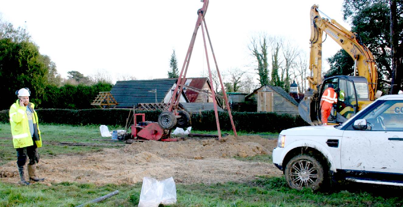
- Digging up Greenfield sites for quick
profits from windfall planning consents is ruining the heritage of
the nation. Once it is gone, it is gone. Britain is short of genuinely
affordable housing that developers are loath to provide where all they
want is the money. It may be that Clarion Housing and Thakeham intend
building affordable units on this site. They should also bear in mind
the requirement for sustainable development in United
Nations terms. Copyright photograph © April 26 2018, Herstmonceux
Museum Limited. All rights reserved. You may not copy this picture
except for educational
use.
|